
8798 Co Rd 13
Bath, NY 14810
USA
This Sunday hike is the second in our BHB Series. This series taking place on the third Sunday of each month for a year, will complete the entire Bristol Hills Branch of the Finger Lakes Trail.
 Sunday’s hike will take us through Pigtail Hollow State Forest, in the Towns of Wheeler and Urbana, beginning about halfway between Prattsburgh and Bath. The Climbers will do the full hike south to north from Access Point 18 to 17, a total of 4.4 miles. The Tourists will hike the southern 3/4 of the trail going north to south, with more descending than ascending. The Tourists and the Climbers will exchange car keys when they meet along the trail, and the Climbers will continue for the final mile beyond the Tourists’ starting point. The Naturalists will start at the same point as the Tourists, going south into the forest to Gramdma’s Camp and exploring some fairly level forest terrain.
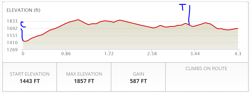
Climbers will start at C and hike north. Tourists and Naturalists will start at T and hike south.
The Climbers hike starts with a steep uphill, moderating to a more gentle climb and then fairly level forest trails with steep stream crossings at a few ravines. There is a good deal of variety in the forest types we will see, including stands of young white pine, older red pine, hemlock on the north slopes, and spruce, as well as oak and other hardwoods. Signage notes some sections of harvested pine forest being returned to native hardwoods. The trail comes out of the woods and follows Hungry Hollow/Dinehart and then Two Rod/Colegrove Road for about a quarter mile, then returns to the woods for the final mile. The Tourists will cover the same trail, but without the final mile, and going the other way (more downhill), from Hungry Hollow Road to County Road 13, for a total of about 3.4 miles (roughly 2 hours).
We will meet at Access Point 18, the southern end of the hike, on County Road 13 (a.k.a. Mitchellsville Road) between Hungry Hollow Road and Randallville Road. There is ample parking along the southern shoulder of the road. This is the starting point for the Climbers, and the end point for the Tourists. Plan to arrive by 3:45 to allow time for organizing cars. Two or three Climbers will leave cars at the final destination, Access Point 17, and then meet the rest of the group at Access point 18 at 3:45. Tourists and Naturalists will then car pool to their hike starting point, where the trail meets Hungry Hollow Road (a.k.a Dinehart Road – a rugged dirt road) near the corner of Two Rod Road (a.k.a. Colgrove Hill Road, also a rugged dirt road). When the Climbers and Tourists meet in Pigtail Forest, they will exchange keys so that the Tourists can retrieve all cars from County Road 13 and bring them around to the north end, reuniting all hikers with their vehicles.
Please upload them here.
[ngg_uploader id=”17″]
From the two end points we will adjourn to the Village Park in Prattsburgh for our social. Prattsburgh has a fine village square with a gazebo and several large tables and bench groups at the center and parking along the sides. Please bring a dish to pass and your own beverage. There is a small grocery store open until 8 PM across the street from the park, for sandwiches and ice cream etc.
To get to Prattsburgh from the end points (the intersection of Hungry Hollow, Dinehart and 2 Rod roads, proceed 2 miles north along 2 Rod (which changes names to Colegrove Hill Road). At the T, make a left on Bean Station Road. At the next T turn right on Route 53. It’s about 5.5 miles total. Don’t miss the Hillview Blueberry Farm on Bean Station Road. You will go right by it, and you can pick your own or buy terrific fresh blueberries already picked, reasonably priced.
Directions to the hike:
From Springwater: Head south on NY 15. At the light in Wayland, turn left on NY 21. In 6.7 miles turn left in North Cohocton to stay on NY 21. (In 1.5 miles, you may turn right onto County Line Rd and follow that to Blodgett Rd and NY53, but it is easier to go into Naples as follows). Continue 4.5 miles to the stop sign on NY 21 in Naples. Turn right onto NY 53. Follow NY 53 for 16.8 miles through Prattsburgh. Turn left onto CR 13 – Mitchellsville Rd. Part on the right side in 1.8 miles. There are signs for the trail on the right and left sides.
From Rochester, Dansville and points north: Take I390 and I86 to Exit 37 and turn left on NY-53 north. Go 5 miles north, through Marshalls, and Wheeler. Take a right on County Road 13 at Renchans. Go 1.8 miles. Shortly after you pass Hungry Hollow Road on your left, you will see the trail crossing CR 13. Park on the right shoulder.
From Naples and points northeast: On the south edge of Naples, take NY 53 south off of Rt 21. Follow NY 53 for 16.8 miles through Ingleside and Prattsburgh to Renchans, where you will turn left onto County Rd. 13. Shortly after you pass Hungry Hollow Road on your left, you will see the trail crossing CR 13. Park on the right shoulder.
From Bath and points south: Take I86 north to Exit 37, and turn left on NY-53 north. Go 5 miles north, through Marshalls, and Wheeler. Take a right on County Road 13 at Renchans. Go 1.8 miles. Shortly after you pass Hungry Hollow Road on your left, you will see the trail crossing CR 13. Park on the right shoulder.
To get from Access Point 18 (south end) to Tourists starting point: From County Road 13, continue south on CR 13 for 0.8 miles. Take the second left onto Runner Rd (AKA Randallville Rd). At the tee (2.4 mi) turn left onto 2 Rod Rd. At the stop sign (1.3 miles) turn left on Hungry Hollow Rd. In 0.2 miles park on the left side by 3 big maple tress. The trail head is back up Hungry Hollow Road directly across from the driveway of a neighbor who would prefer that we not park in front of the house.
To get from Tourists starting point to Access Point 17: Go east on Hungry Hollow Road, through the intersection where the name changes to Dinehart Road. Make a left when onto Glen Brook Road at the second intersection. In 0.2 miles, the trail crosses the road. There is a small kiosk and parking area on the right side of the road.
[ngg_images source=”galleries” container_ids=”17″ display_type=”photocrati-nextgen_basic_thumbnails” override_thumbnail_settings=”0″ thumbnail_width=”100″ thumbnail_height=”75″ thumbnail_crop=”1″ images_per_page=”20″ number_of_columns=”0″ ajax_pagination=”0″ show_all_in_lightbox=”0″ use_imagebrowser_effect=”0″ show_slideshow_link=”1″ slideshow_link_text=”[Show as slideshow]” order_by=”sortorder” order_direction=”ASC” returns=”included” maximum_entity_count=”500″]
An additional note of opportunity: For history buffs in the group, the Narcissa Prentiss House (essentially a museum of Narcissa Prentiss’ home) is open on Saturdays & Sundays in July & August 1-4PM. Free admission, donations accepted.